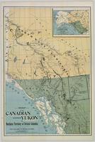
Map of the Canadian Yukon and Northern Territory of British Columbia
Image


Map of the Canadian Yukon and Northern Territory of British Columbia
| Persons |
Persons
Associated name (asn): R. Edward, Gosnell, 1860-1931
|
|---|---|
| Collection(s) |
| Origin Information |
|
|---|
| Subject Topic |
Subject Topic
|
|---|---|
| Geographic Subject |
Geographic Subject
|
| Temporal Subject |
Temporal Subject
|
| Physical Form |
Physical Form
|
|---|---|
| Content type |
Content type
|
| Resource Type |
Resource Type
|
| Genre |
Genre
|
| Language |
Language
|
| Local Identifier |
Local Identifier
FC3811.6.M36 1897
|
|---|---|
| Handle |
Handle
Handle placeholder
|
| Use License |
Use License
|
|---|
| Persons |
Persons
Associated name (asn): Gosnell, R. Edward
|
|---|---|
| Collection(s) |
Collection(s)
|
| Origin Information |
|
|---|
| Geographic Subject |
|---|
| Physical Form |
Physical Form
|
|---|---|
| Content type |
Content type
|
| Resource Type |
Resource Type
|
| Genre |
Genre
|
| Language |
Language
|
| Local Identifier |
Local Identifier
FC3811.6.M36 1897
|
|---|---|
| Handle |
Handle
Handle placeholder
|
| Use License |
Use License
|
|---|
unbc_54704.jpg40.79 KB
Download
| Language |
English
|
|---|---|
| Name |
Map of the Canadian Yukon and Northern Territory of British Columbia
|
| Authored on |
|
| MIME type |
image/jp2
|
| File size |
8160253
|
| Width |
9359px
|
| Height |
13931px
|
| Media Use |