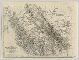
Summary Persons Persons Author (aut): Waddington, Alfred Collection(s) Collection(s) NBCDC Maps and Plans Origin Information Origin Information Place London Date Created/Date Issued 1868 Publisher Published for the Journal of the Royal Geographical Society by J. Murray, Albemarle Street Subjects and Classifications Subject Topic Subject Topic British Columbia -- Maps. Library of Congress Classification Library of Congress Classification G3510 1868 .W3 Resource Description Extent Extent 1 map : colour ; 19 x 26 cm Physical Form Physical Form map nonprojected graphic Content type Content type Image Resource Type Resource Type Still image Genre Genre map Language Language English Identifiers Handle Handle Handle placeholder Notes Note Note Type statement of responsibility Note by Alfred Waddington. Access and Rights Use License Use License Public Domain Mark 1.0 Universal